Unraveling Old Brussels
Following my Project Oud Leuven 1649, I am embarking on a new journey with this project to discover the original Brussels using an old map dating from 1572. After Brussels has taken over Leuven as the capital and seat of government of the Duchy of Brabant, it later became the capital of the Imperial Netherlands under the Habsburg Empire. Together, we will uncover this original Brussels of the rich Brabantian culture and history that now seems to have been lost under the layers of modern-day Belgium.
What are the buildings that have remained? How do things look like today, compared to a few hundred years ago? Using Google Map and Google Earth, I superimposed the old map onto the modern day navigation map in order to find the exact location of the lost and existing sights.
Join me in my quest to explore Old Brussels!
The Map of 1572
The map I am using was printed in 1572. It belonged to the first dome entitled “Civitates orbis terrarium” of a six part series of maps produced between 1572 and 1617 by Frans Hogenberg a cartographer printer based in Cologne and Georg Braun, canon of the city’s cathedral. The reason why I chose this map is that it is the earliest map with the original Dutch names of buildings and places of Brussels that have been lost to time.
“Het werk is de grootste verzameling plattegronden en illustraties die ooit is verschenen. De stedenatlas bevat 546 kaarten en stadsgezichten van alle belangrijke steden in Europa en steden in Azië, Afrika en Latijns-Amerika. Ruim honderd kunstenaars en cartografen hebben meegewerkt aan deze atlas, die niet alleen plattegronden van steden laat zien maar ook afbeeldingen van mensen in hun landelijke kleding, schepen en topografische afbeeldingen van stad en land.” (Source)
Click below if you wish to download the image file of the map in JPG.
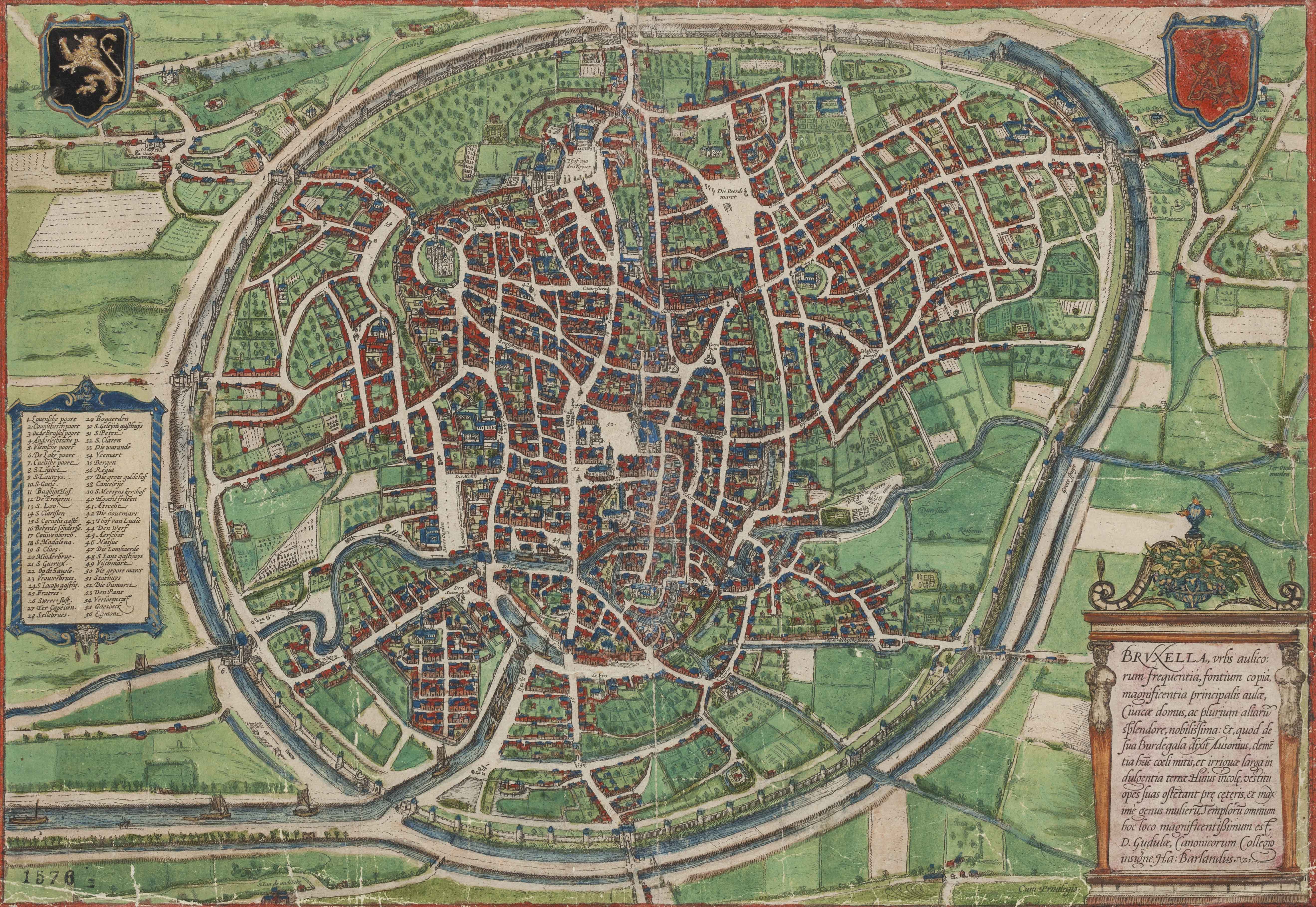
List of 56 Sites of Oud Brussel in 1572
As you can see on the 1572 map of old Brussels, the sites are numbered and there is a Legend on the left with the names of each numbered Key. For each of the sites, I produce a page numbered accordingly as on the 1572 Map. Each site is marked with the original 16th century name, in the Brabantian Dutch in contrast with the modern Dutch version. I have also provided later names, either still in Dutch due to popular names or later names in French that came from the 19th century latinization process that accompanied the gentrification and migration stemming from industralisation. Each page tells you the precise location of the site on Google Map, as well as photos of its current state. On top of that, I have found some really interesting sites which are drawn on the map but are unmarked, yet offer a surprisingly interesting perspective today.
Legend:
- [ ] : Faulty attributions made by the cartographer.
- *: Site does not exist anymore and is not replaced by a significant building on the same spot.
I. – XXVIII.
- Lovensche poorte
Leuvensepoort
Leuvensepoort, Porte de Louvain, Madou - Couyeberch poort
Nieuwe Koudenbergpoort
Naamsepoort, Porte de Namur - [Oude Brußel poort]
Obbrusselpoort
Hallepoort, Porte de Hal - Anderlechrsche p
Anderlechtsepoort
Anderlechtsepoort, Porte d'Anderlecht - Vlemsche poort
Vlaamsepoort
Vlaamsepoort, Porte de Flandres - De Lake poort
Lakensepoort
Intersection Emile Jacqmainlaan-Koning Albert II laan - Cuelsche poort
Keulsepoort/Schaarbeeksepoort
Financietoren, Tour des Finances - S. Lijsbet
Sint-Elisabeth op de berg Sion
Drukkerij van de Nationale Bank, Imprimerie de la Banque Nationale - S. Laureÿs
Sint-Laurentiuskapel
Drukkerij van de Nationale Bank, Imprimerie de la Banque Nationale - S. Goele
Collegiale kerk van Sint-Michiel en Sint-Goedele
Kathedraal van Sint-Michiel en Sint-Goedele, Cathédrale Saints-Michel-et-Gudule
- BaghijnHof
Begijnhof
Hospice Pachéco - De Prekeren
Predikherenklooster
The Dominican, Muntschouwburg/La Monnaie - S. Loo
Sint-Lookapel
Muntpunt - S Clarißen
*Arme Klaren Grauwzustersklooster
Vander Elststraat, Rue Vander Elst - S Cornelius gasth
*Sint-Corneliusgasthuis
39-65 Vlaamsesteenweg, Rue de Flandre - Bekerde Sondersse
Maria-Magdalenaklooster
Grétrystraat, Rue de Grétry - Couwenberch
Sint-Jacob-op-de-Koudenbergkerk
Eglise Saint-Jacques sur Coudenberg - S Madalena
Maria-Magdalenakerk
Église de la Madeleine - S Claes
Sint-Niklaaskerk
Église Saint Nicolas - Minderbrue
*Minderbroedersklooster
Beursplein, Place de la Bourse
- S Guericx
Sint-Gorikskerk
Sint-Gorikshallen, Halles Saint-Géry - Op de Sauele
Onze-Lieve-Vrouw-ter-Zavelkerk
Onze-Lieve-Vrouw ter Zege op de Zavelkerk, Église Notre-Dame des Victoires au Sablon - Vrouwebrues
*Karmelietenklooster
Lievevrouwbroersstraat, Rue des Grands Carmes - S Iacopsgasthz
St-Jacobsgasthuis
Onze-Lieve-Vrouw van Goede Bijstand, Église Notre-Dame de Bon Secours - Fratres
Nazarethklooster van de broeders van het Gemene Leven - Swerte Sust
*Zwartzustersklooster
Groot Eiland, Rue de la Grande Ile - Ter Capellen
Onze-Lieve-Vrouw-ter-Kapellekerk
Kapellekerk, Eglise de la Chapelle - Sellebrues
Cellebroedersklooster, Godshuis van de Broeders van de Derde Orde
XXIX. – LVI.
- Bogaerden
Bogaardenklooster - S. Geleÿns gasthuÿs
Sint-Gillijnsgasthuis, Sint-Juliaangasthuis - S. Peter
Sint-Pieters-ter-Zieken - S. Claren
Klooster der Rijke Klaren - Die Warande
De Warande - Veemart
Veemarkt - Bergen
Hof van Bergen - Regia
Paleis op de Koudenberg, Hof van Brussel
Koninklijk Paleis te Brussel, Palais Royal de Bruxelles - Die Grote Guldehof
Grote Gulden Hof - Cancelrije
Kanselarij
- S Mertens kerchof
Sint-Maartenskerkhof - Hoochstraten
Hof van Hoogstraten - Atrecht
Hof van Atrecht, Granvellepaleis - Die houtmart
Houtmarkt - Thof van Ludic
Hof van Ludic - Den Werf
De Werf - Aerschot
Hof van Aarschot - Nassue
Hof van Nassau - Die Lombaerde
Bergen van Barmhartigheid - Lombarden - S Ians gasthuys
Sint-Jansgasthuis
- Vischmart
Vismarkt - Die groote marct
De Grote Markt - Stathuys
Stadhuis - Die Outmarct
De Oude Markt - Den Pant
De Pand - Verloren cost
Verlorenkostpoort, Filipspoort - Gaesbeck
Huis van Gaasbeek - Egmont
Egmontpaleis
Extras
Brvxella, incomparabili exemplo septenaria, 1646
The Seven-fold Wonders of Brussels, 1646
After the death of his mentor Justus Lipsius (1547-1606), humanist scholar Erycius Puteanus (Eric van de Putte) (1574-1646) returned to Leuven with his wife in 1606. From 1614 onwards, he lived in the castle on the Keizersberg. From Leuven, he visited the cities around the Duchy of Brabant, and especially Brussels. The result of his visit was a book entitled “Brvxella, incomparabili exemplo septenaria“. After this book, Erycius Puteanus also came up with the Seven Wonders of Leuven. The number Seven has been a fascination for humanists like Puteanus as it mirrors the Seven Wonders of Antiquity. In this “Seven-fold Wonders of Brussels“, Puteanus described in seven poems, the seven churches, seven hospitals, seven bridges etc of Brussels. Notably, Puteanus also listed the genealogy of the Seven Patrician Families of Brussels :
- Coudenberg
- Roodenbeke
- Serhuyghs
- Serroelofs
- Sleeus
- Steenweeghs
- Sweerts.
What may be fascinating for today’s readers are the woodcuts of Brussels’ main sites back in the seventeenth century.
The idea here is not to list down all these seven wonders, but to supplement sites not listed in the 1572 map.
Straten
Streets
- Anderlechtse Steenweg
- Bergstraat
- Borgendaal
- Cantersteen
- Corbaro
- Crekelendries
- De Grote Raam
- Den Zaterdag
- Drie Molens
- Duerslach
- Guldestraat
- Hoogstraat
- Jodentrappen, Jodenpoel
- Lange Ridderstraat
- Mansfeld
- Paardenmarkt
Zavel, Sablon - Putborre
- Rosbemd
- Schipbrugge
- Sint-Katelijnedok
- Steenweg
- Swaene Straete
Ooievaarstraat, Rue de la Cigogne - Vijfhoek
- Volderstraat
- Waalse Plaats
- Warmoesbroek
Kerken
Churches
- Sint-Annakapel
- Sint-Joost-ten-Node
- Sint-Katelijnekerk
Kloosters
Abbeys
- Regularissenklooster Onze Lieve Vrouw ter Rosen gheplant in Jericho*
Gebouwen
Buidings
- De Munt
- Het Manneke Pist
- Hof van Arenberg
- Korenhuis
Eerste Omwalling
Inner City Walls
- Annessenstoren
- Bogaardenwiket
- Driesmolenwiket
- Koudenbergpoort
- Lakenpoort
- Leeuwswiket
- Oude Spui
Fontainasplein - Overmolenpoort
Sint-Jakobspoort - Plebaantoren
- Ruisbroekwiket
- Sint-Goedelepoort
Treurenbergpoort - Sint-Katelijnepoort
- Steenpoort
Kapellepoort - Villerstoren
- Warmoespoort
- Wolfswiket
Sint-Janswiket - Zwarte Toren
Tweede Omwalling
Outer City Walls
- Blauwe Toren
- Groot Spui
- Klein Spui
- Vaartgat
Oeverpoort - Wollendriestoren